Technology influences our world to become a more efficient, safe, and precise environment. Likewise, the progression of tech devices creates pathways to complete more tasks with higher efficiency. This alters the way we and future generations will live and work. Consequently, as personal and professional dependency on technology increases, a demand for geospatial industries to engineer devices that establish stable connections in GNSS impaired environments arises.

City planning requires precise mapping
The 21st century is on the tipping point of having four fully operational systems in place. Yet, many still manage to stumble into places where GNSS tech lacks a connection. Typically, connection issues are caused by an obstruction of satellite signals. Buildings, terrains, and many other man-made or natural objects can cause disruptions. Furthermore, GNSS satellite signals are traditionally weak, easily interruptible, and comparable to a 50-watt lightbulb.
The need for real-time high-accuracy GNSS positioning is growing. Despite regulatory requirements on spatial data accuracy rapidly increasing, some industries refuse to accept less than the utmost precision. Highly accurate horizontal and vertical data may already be achievable in some areas, but the demand for high-accuracy positioning drives us to innovate and collaborate on devices that can fill a centimeter-accurate void where GNSS will not work.
Industry demand for precise accuracy at locations with hard-to-reach assets produces a complete solution. Eos Positioning Systems, Inc®, Esri®, and Laser Technology, Inc, come together to create the world’s first Laser Mapping Offset workflow within the Esri ArcGIS® Collector®. Modified hardware and software makes this Laser Mapping Offset solution compatible with iOS devices. As a result, you can Bring Your Own Device (BYOD) and achieve high-accuracy measurements with the hardware you already own.
The Esri portion of this solution was tailored to use ArcGIS Collector. Check out this ArcGIS blog and clip from Esri on how ArcGIS captures high-accuracy data using a GPS or GNSS receiver:
Video: Capture high-accuracy data with Collector
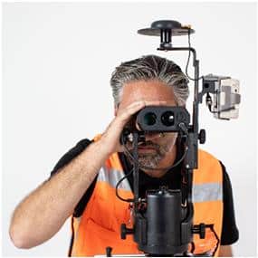
TruPulse 360R Integrated Laser Offset mapping Solution
Combined with ArcGIS Collector, Eos® Arrow® Gold GNSS Receiver, is the first high-accuracy iOS, Android®, and Windows Bluetooth® receiver to implement all four global constellations, three frequencies, and satellite-based RTK augmentation. Compatibilities of LTI devices allows you to integrate to practically any system and workflow!
Laser Technology’s TruPulse® Laser Rangefinders easily integrate into Eos Tools Pro app, or your existing GIS solution. This allows you to capture repeatable, 3D, and highly accurate measurements without needing to occupy every data point. When using high-accuracy GPS/GNSS devices, everything you collect is based off precise control points. As a result, the most highly valued benefit of laser mapping is an ability to occupy a single, convenient, and safe location, which provides the freedom to map as many assets as possible.
LaserGIS is our term for using TruPulse laser rangefinders as an integrated tool within workflows that allow users to assign coordinate and characteristic data to assets without physically occupying their location(s).
The combination of these powerful solutions helps eliminate mistakes. This is accomplished by capturing accurate dimensional measurements and automatically entering them in as attribute data. Moreover, the solution streamlines workflow efficiency and maintains RTK-level accuracy in traditionally troublesome areas.
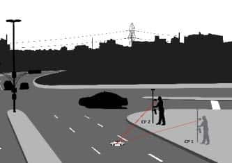
Range-Range Laser Offset Mapping Method
Range-Range
Range-Backsight
Range-Azimuth
To learn more in-depth about these routines, see this video on Eos Laser Mapping Integration. In addition, enjoy these laser mapping videos that take you through the full step-by-step details of the world’s first and only laser rangefinder mapping solution for ArcGIS® Collector!
Contact us today for more information about LTI's laser mapping products and solutions, or to schedule a practical demonstration.
Contact Us