Measurement solutions to collect reliable field spatial data for all types of utility disciplines including electric, gas, water, pipeline and telecom.
Our TruPulse® laser rangefinders do not require reflectors, eliminating much of the time investment needed to collect field data.
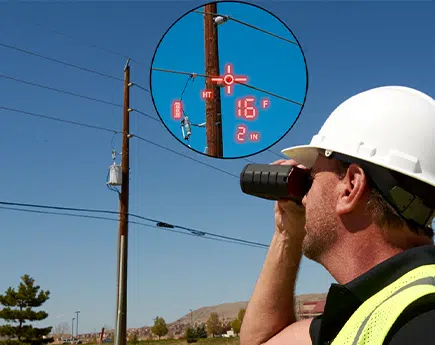
See the TruPulse lineEach specialization in electric utilities has a different workflow, and varied application of skills. Laser Tech’s TruPulse® line of laser rangefinders are compact enough to fit in a vest pocket, boast superior optics giving you the ability to measure directly to a conductor, and have onboard calculations for the work you do. So however your workflow looks, these solutions save you field time by reducing the equipment you might need to carry around (like height sticks) or extra work required like placing a reflector on the wire.
Download the Professional Measurement Product Solutions Brochure.
NESC regulations and permits require space management on utility poles for communication, supply, and safety zones to be measured and recorded accurately, and taken periodically.
Pole audits/surveys are conducted by field workers to ensure all assets on a utility pole do not present dangers and are to code. Inspectors evaluate sagging wires, attachments to the pole, height of attachments and distance between them, and whether not there is any vegetation or any other possible dangers close to the poles and wires.
From GNSS remote locations, wire separation, attachment heights of assets, roadway clearances to measuring span, and line sag to adjacent poles, LTI’s solution is easy to learn, safe to operate, simple to record, and quick to transfer back to the office.
Download the LaserSoft Joint Pole Brochure.
For O-Calc product users, download the LaserSoft Pole Audit for O-Calc Brochure.
Current ways of performing and documenting an audit can be expensive, labor intensive and sometimes even dangerous. LTI’s solution is easy to learn, safe to operate, simple to record and quick to transfer back to the office.
Learn how to collect clearance measurements to calculate missing line values for Electric Utility Applications with TruPulse laser rangefinders.

NESC guidelines for adequate vegetation clearance around power lines prevent major power outages caused by trees hitting the lines and the resulting property damage from fires. TruPulse laser rangefinders have been the go-to solution for many years because they are easy to use, provide repeatable results, and offer unmatched flexibility in the field. Confidently measure the right-of-way widths, heights of trees, encroaching vegetation, and tree to conductor clearances.
Download the Laser Tech for Vegetation Management Article from T & D Magazine.
In-scope conductor separation demonstration of the TruPulse 200 laser rangefinder 2D missing line routine.
Determine upgrade capacity and power efficiency for existing power lines, accurately tension newly constructed lines and assess conductor clearance over roadways. Our reflectorless TruPulse laser rangefinders quickly and easily measure spans, widths, heights for clearances, and collect all the data you need to calculate sag and tension.
Sag Profiler is a field data collection app program that electric utility professional use to measure the span, sag, and tension of conductor wires. Directly measure to conductors hanging between two attachment points.
Download the LaserSoft Sag Profiler Brochure.
Vegetation management is just one of thousands of applications that need to measure a clearance value. You may need to know the clearance under a bridge or the distance between 2 remote points.
Learn how to collect a simple sag measurement using the missing line routine. Demonstrated with a TruPulse 200.
Learn how to collect clearance measurements to calculate missing line values for Electric Utility Applications with TruPulse laser rangefinders.
In-scope demonstration of a 2D missing line routine for finding a conductor attachment separation using a TruPulse 360° laser rangefinder.

Asset and facility mapping is a critical element in the pipeline industry when undertaking a major GIS project. Avoid dangerous trench terrain and the hassle of obtaining permission from landowners to locate your above ground and buried assets. Occupying dangerous or hard-to-reach areas is an easily overcome obstacle with the addition of TruPulse laser rangefinders to your GNSS location workflow. GIS apps can calculate remote coordinate locations for all features within sight.
Laser measurement systems acquire non-contact data directly to your features from a safe location for:
Learn how to collect slope measurements using a TruPulse 200 model (without compass) for construction applications.
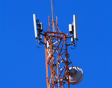
Precise network design, signal strength optimization, and inventory positioning all demand proper tower placement. From a safe location, TruPulse laser rangefinders efficiently acquire measurements directly to attachment points, conductors, vegetation, or anywhere along the lines. Make your job easier and safer by measuring directly to all types of targets without the need for a reflector.